ROADS AND DRIVING
 As you leave Valladolid, on nicer roads then any in Michigan, the scenery changes, no longer are you in a bustling city but now dense lowland scrub vegetation coats the flat land ahead. The first time my mother came to this part of Mexico she told me she saw why I was so comfortable, it was the same flat terrain we had in our part of Michigan.
Yet with this trip I found out, as one moves south of Josè Marìa Morelos the ground rolls up forming limestone protuberances, mountain monsters whom look as though they are slumbering in the distance. Coming from Michigan the roads themselves are like fresh laid blacktop – something that only exists for a matter of months in my world before winter’s salt does her damage. As you drive, you quickly see a historical story play out in village after village.
OUR ROUTE
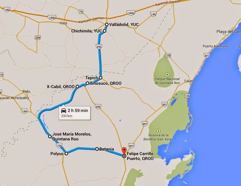
When the Spanish descended upon a region to convert them they left a trail of colonial churches, convents and out of place architecture. Unfortunately due to time constraints we were not able to stop at all the wonderful churches on Ruta de las Iglesias; including Tekom, Tixcacalcupul, Huay Max, Saban, Sacalaca to name a few. We were able to stop at these this trip (and will eventually visit the others).
· Tepich
· Tihosuco
· Xcabìl
· Polyuc
· Betania
Make sure to have plenty of MXN pesos as I saw no ATMs or banks along the way. Fill your car with gas before you leave Valladolid and again at Josè Marìa Morelos and Felipe Carrillo Puerto. Besides street carts at the central zócalo, which were at almost every village, there are not many other places to get food in these small communities.
TRAVELING THE RUTA DE LAS IGLESIAS
MX 295 and MX 184 are roads that would be easy to navigate at night once you have done it during the day. The highway speed varies drastically along the route, sometimes without a pattern; 40km per hour to 110km per hour. Despite the speed limits some will zoom around you and other will putt along loaded to max with items they are taking to market.
TOPES
Topes are Mexico’s version of speed bumps but they are much more effective than ours. They look like half a steel cannon ball about 9” in diameter, sunk in the ground in a perfectly straight row perpendicular to the road.
Most sit 50 or 100 feet before and after a village, which makes sense, to slow those speeding on the deserted highway before they enter the town. Most are marked by a yellow tope sign AT the topes themselves, few have signs that warn you ahead time to slow down. Others literally sit in the middle of nowhere or at a place that used to exist and no one bothered to take the topes with them when they left. Though a nuisance, as you must slow to 5 mph to avoid doing severe damage, they are nothing more than that unless you hit one going 60 mph then you will need a new tire and possibly a rim.
Topes are the main reason people tell you not to drive at night in Mexico, if you are unfamiliar with the area it is hard to see the yellow signs at the tope in time to slow down, especially at night. Keep your eyes peeled for the yellow tope signs and you should be fine.
NAVIGATING
Have a GPS, Google directions or somewhat current map of the route and it cities with you because there are very distance signs and you will have to keep track of where you are by the last city you passed through. Online directions and GPS may not be as accurate or clearly marked and you may still need to ask for additional help to find the exact location, be patient. All those whom we asked for directions were glad to help and even those who spoke only Yucatec Mayan and could not understand English or Spanish would point out the way when we hit a key word they recognized.
DAYLIGHT
Another thing to be aware of is that night falls around 6 pm year round. For many this is not an oddity or new concept for us Northerners (especially Michigander) it is. We are used to wide shifts in daylight throughout the year; in the warm summer months night falls between 9 and 10 pm, during the freezing winter months nights beats you home from work coming between 5 and 6 pm. In the Yucatan warm weather does not equal long days; daylight is gone by 5:30 or 6 pm year round.
SAFETY OF YUCATAN PENINSULA
We traveled through many small villages in the middle of nowhere, never once did we feel uncomfortable. Even though we stuck out like a sore thumb, traveling with a day-glow white lady, myself, and a pink haired teen daughter will do that. Despite the fact we were easily recognizable “outsiders” we were more than welcomed throughout our trip. At times my daughter attracted a lot of attention because her pink hair made her look like one of the contemporary cartoon characters that adorn all the toys and kid clothes. In Chichimila the elementary had just let out creating a flood of children with huge smiles who stared and gawked and surrounded the car in excitement. It was quite wonderful.
WHAT TO EXPECT TO SEE WHILE DRIVING
In between villages, or blips on the map, is dense low-lying jungle cut clear by a driveway ever so often. Pay attention to the shoulders of the road along the sides of the highway, or any road, as men will park their bike, trike or vehicle on the shoulder and venture into the woods hunting or gathering fallen lumber for firewood or carvings to sell at market.
Sometimes these men will be riding their bike with a machete or rifle crossing their back as their legs spin them to their next destination. Do not fear them they are simply surviving, they are not vigilantes or menaces, they are simply looking for their next meal. You will also see mopeds and automobiles packed to the gills with people or products as they try to carve out a living in this vast terrain.
Just prior to Tepich, in the middle of what seemed to be nowhere, lays a dilapidated Spanish arch. Its pure beauty forced us to stop and take it in. You knew years ago this signified the greatness you were entering, grandeur laid ahead. May be they were proving themselves to Chichimilà or showing what they could do. Now it sits like a paused moment in time reminding us of what used to be.
CITY LAYOUTS
On (ejido) communal traditional Maya lands there is a central courtyard, el centro or zócalo that houses a plaza with a stage, basketball courts, covered communal areas, an old colonial Spanish church and a variety of houses (sprawling across several streets or clustered in several square block subdivisions).
Spanish Colonial Churches still sit prominently in the centers of the Maya Villages; most atop small elevations or former Maya Temples, others were simply built tall enough to demand the town’s attention. Even today the colonizers’ churches hold a watchful, albeit judgmental, eye over its inhabitants.
A reminder of the harsh oppressive past that has long culminated and melded with contemporary Mayas world view while leaving them unaware of the dominance that has loomed over them for 100s of years. Creating a strong short people who tell the stories of their ancestors in an ancient tongue while celebrating the God and goods of their conquerors and melding the two to create something uniquely their own.
This layout allows for easy navigation in many of the villages and small towns as the old churches are usually centrally located and easily visible from the cities edge
MAYA HOMES
There are a variety of house styles. Some are scattered through the rural areas, others flank the small village roads and even more cluster in the several “city” blocks the village have. True huts; constructed solely of wood and palm fronds in the same manner they were a thousand years ago. Others have raised concrete pedestals with sunken walls and fronded roofs, a semi-modern form if you will.
Some, “modern” huts, are circular concrete homes topped with a traditional palm frond roof. Every so often there is a rough looking contemporarily designed concrete box with a flat roof, a single front window and door, which though more “modern” remind me of a prison cell. Occasionally we saw a simple ranch home, similar to any you would see in rural United States.
Most homes, or family groups of homes, are surrounded by a short stone wall, 2-3 feet or a meter high, marking the house lot boundary line and containing a single home or more traditionally a group of related family homes. Within these lot lines lies a shared space or “kitchen” known as a solares (Fletcher and Kintz), a contemporarily used example of Classic Maya architecture and cultural organization that is seen throughout the Yucatan and Quintana Roo states today.
A solares houses a sink, stove or grill or both, a kitchen garden and orchard. It also marks the family unit to the outside world while establishing the members’ social statuses within its borders. Amazing how something, to my American 6 foot privacy fence standard, so short and small could say so much about a specific place and the people in it (Fletcher and Kintz).
Leave a Reply